505-980-2499

FAQ
Q: What geographic areas do your cover?
A: I cover the entire state of New Mexico, Southern Colorado and El Paso.
Q: When do you use an airplane vs a helicopter?
A: The answer is determined by the need, specifications and the budget of a project. It is less expensive to use an airplane. Most aerials need to be taken from an altitude of 1000 feet or higher to obtain the best perspective.
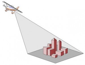
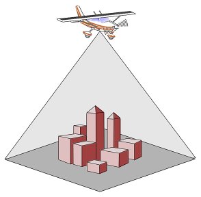
Q: What is the difference between a vertical and an oblique photo?
A: Oblique (Left graphic) is at an angle from the subject giving a 3 dimensional view vs being directly overhead (Right graphic) similar to what is used in mapping.
Q: What is the turn around time once I place an order?
A: Once we receive an e-mail confirmation to proceed, we schedule the assignment, weather permitting. The photo proofs are posted on-line for review. Once the images are selected and the final product is known, delivery time is within one week.
Q: Can you provide labels like roads, property outline and landmarks?
A: Yes. We can place it digitally into the photo. We can even add your logo.
Q: How do I view the proofs of the work you have done?
A: You will receive a link in an email.
Q: What is the best way to get a hold of the office?
A: Call 505-980-2499 or e-mail lee@eagleseyephoto.com
Aerial photography has become an extremely useful and valuable management tool during the construction of a project. A few reasons include settling legal disputes, material deliveries, equipment on site, draw reports, land errosion, owner and community meetings. Therefore, it is important that a contractor locates a qualified aerial photographer.